Aldermen approve plan to manage sediment in Lake Tomahawk
The Town of Black Mountain is initiating a process to address sediment accumulation in Lake Tomahawk.
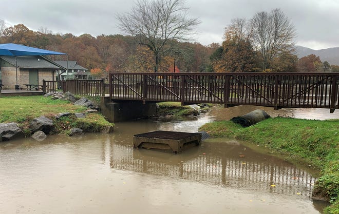
Aldermen, in their October regular monthly meeting, approved a $72,000 contract with Wildlands Engineering to design and replace the current system, north of the pedestrian bridge, which was damaged by flooding in 2018.
“That’s where our forebay is,” Town Manager Josh Harrold told the board while presenting the proposal. “A number of years ago there was a structure put in that allowed water to flow into a concrete box when it got up too high. The water would then go into the lake through a pipe, while the sediment remained on the north side of the bridge.”
Flooding in May and September of last year washed out an earthen embankment under the bridge, according to Harrold. The damage allowed sediment, suspended in the water from Tomahawk Branch, to flow into Lake Tomahawk.
“This proposal you have in front of you is for a couple of different things,” the town manager told the board. “The engineering for the project is in the range of $32,000 - $36,700. Construction work to re-do the forebay in a different fashion, which would eliminate that pipe and box, add a rock arch weir and include stream restoration north to Laurel Circle Avenue, would be another $36,700.”
The failure of the embankment and pipe structure has been “an issue,” Harrold added, citing the town’s efforts to improve the quality of the Swannanoa River, which receives water from Lake Tomahawk.
“We implemented a Swannanoa River Restoration Plan a number of years ago in an effort to remove the river from the (N.C. Department of Environmental Quality 303 (d) list),” he said. “The river is impaired due to sediment.”
Tasks associated with the engineering of the first phase of the two-phase project will involve removing the failed box and pipe structure, re-centering the creek under the bridge, collecting data to support a sediment management plan and working with the town to establish a dredging plan for the forebay, according to the proposal from Wildlands.
The process would also include an assessment of the pedestrian bridge abutment, conducted by Bunnell Lammons Engineering.
“That abutment received damage during the floods, but we’re not sure how much damage,” Harrold said. “The proposed contract does not include repairs to the bridge, but it will determine whether or not that abutment has been compromised.”
The contract with Wildlands includes three meetings with town staff during various stages of the project and an assessment that includes a topographic survey of the stream. Wildlands will secure the necessary environmental permits before preparing the design and construction plans for the project.
Harrold presented the board with a schematic design of the proposed project, which depicts dredging of a 3,500-square-foot area upstream from the forebay. The rock weir will be constructed 20 - 40 feet north of the pedestrian bridge, creating a “backwater zone” designed to trap sediment and allow for regular dredging.
The plan also calls for rebuilding the bank of the creek on the east side of the bridge and replacing material under the west side of the bridge with stone.
“Our hope is that by doing it this way, as opposed to the system we had in place before, it will function a little more naturally,” Harrold said. “Once we have this work done, we will begin a second phase where we involve multiple agencies to work on a plan for managing the sediment in that area that we can use to address it going forward.”